- A. Reijndorp, Like Bijlsma, Ivan Nio. Atlas Nieuwe Steden. De verstedelijking van de groeikernen, Haarlem/Rotterdam: trancity*valiz, 2012.
- Faludi, A. en A.J. van der Valk, De groeikernen als hoekstenen van de Nederlandse ruimtelijke planningsdoctrine, Assen/Maastricht: Van Gorcum, 1990.
- Niek de Boer, Donald Lambert. Woonwijken: Nederlandse stedenbouw 1945-1985. Rotterdam: Uitgeverij 010, 1987.
- Martien de Vletter. De kritiese jaren zeventig, architectuur en stedenbouw in Nederland 1968-1982. Rotterdam: Uitgeverij 010, 2004.
- W.J. Pantus. Groeikernen in Nederland: Een studie naar stedenbouw en architectuur, Utrecht: Stichting Matrijs, 2012.
- Carola Peters-van der Gouw (red.), Capelle aan den IJssel: de geschiedenis (Capelle aan den IJssel 1991).
- H.A. Voet, Capelle aan den IJssel in oude ansichten (Zaltbommel 1979).
- Paul Weyling, Capelle toen en nu. Geschiedenissen en herinneringen uit Capelle aan den IJssel (Capelle aan den IJssel 1998).
- Paul Weyling, Capelse historie. ‘Vroeger hoort erbij’ (Capelle aan den IJssel 2005).
type of New Town:
> scale of autonomy
New-Town-in-Town
Satellite
New Town
Company Town
> client
Private Corporation
Public Corporation
> policy
Capital
Decentralization
Industrialization
Resettlement
Economic
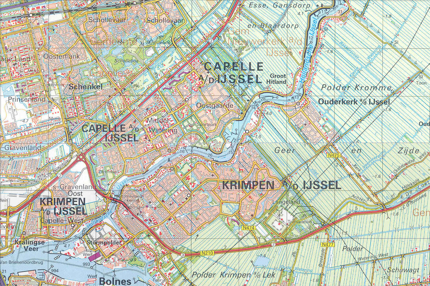
source: Grote Topografische Atlas van Nederland - http://www.kuijsten.de/atlas/zh/capelle.html
Context of its foundation
In 2001 the last big expansion of Capelle aan den IJssel was started with the new district 'Fascinatio'. After the completion of this district an end has come to the strong growth that the community has seen in the last decades. Since the completion of Fascinatio Capelle aan den IJssel can only plan to build into the height on its own grounds such as two high-rise blocks of flats of 60 m in the business area the Wormerhoek.
Because all the available ground within the city limits have been build to their full extend, talk today is of the so-called 'inbreeding'. That means that outdated housing complexes and other buildings are destroyed and replaced with newly built houses and projects. All aimed at improving the existing area. To get more diversity in the building heritage, these houses are more and more build with the aim to sell them to consumers instead of building for the rental market.
It's clear that the large majority of future new housing projects will have to come from redevelopment within the city borders.
Initial development
Historically seen the main sources of business in Capelle aan den IJssel have always been agriculture and fishery. But during the 19th century, stone factories became the new important businesses. Next to that shipbuilding yards started to develop.
Today most inhabitants of Capelle are not anymore dependent on the businesses within the city limits for their work and income. Most have found employment in the greater Rotterdam region.
Biography of the town
Capelle aan den IJssel dates back to 1200 and grew over the centuries from a small community on a river dike to the living and bustling city of today.
The inhabitants of Capelle aan den IJssel have always been closely related with the river and water. From the Middle Ages people were mainly busy with digging 'turf' from the soil, the main source of fuel in those days! Due to these actions that happened over many centuries the soil clogged, more 'turf' was taken out, soil levels became lower and ponds and small lakes were formed adjacent to the river.
Flooding
There was a big danger of flooding with a flowing river that is also influenced by the tide level of the North sea, so dikes were build to protect the town in the seventeenth century. Later on, they also started with the 'droogmakerije'n, the famous Dutch 'Polders' like the 'Prins Alexanderpolder' that was finished in 1874. Still the deepest polder ( minus 6+ m. below sea level!) of the Netherlands. Today a substantial part of Capelle aan den IJssel is build on this reclaimed land.
Capelle aan den IJssel was also in the reach of the famous inundation in 1953. When a large part of the southwestern part of The Netherlands was flooded due to an extreme combination of a serious super storm with a spring sea tide. The damage in Capelle was fortunately not so severe. But as a result in 1954 it was decided to start building the 'Deltaworks', part of it being the Stormvloedkering Hollandse IJssel, in combination with the Algerabrug, which connects Capelle aan den IJssel with its neighbour community 'Krimpen aan den IJssel'. In 1958 these works were finished, so this year the community celebrates the 50th anniversary.
In the city planning of Capelle aan den IJssel the continuous factor was the ongoing struggle with big brother neighbor city of 'Rotterdam'. End result is an illogical, inconsequent, borderline between the two cities.
After World War II in 1945 there has been an explosive urban development.
The growth of Capelle aan den IJssel is devised on the old Rotterdam ideas of a finger like structure in the expansion of a city. Like everywhere in Holland, the Rotterdam area started to build big quantities of houses and buildings with community facilities.
Most of it was build by traditional methods, but ten years later more by industrial construction methods took over.
The development of the 'volkswoning', houses for the working people, was paramount. Town planning was the main focus in those years. Social responsible housing projects were developed everywhere.
In the fifties of the last century there were ambitious plans in the Rotterdam region to further develop the area. In the sixties there was even a grand idea to build a new town in between Rotterdam and Capelle aan den IJssel: 'Alexanderstad'. These very ambitious plans ended somewhere in a dark drawer.
The focus of all concerned will have to reflect this attitude.
The community Capelle aan de IJssel has a couple of shopping malls like De Scholver, De Terp en De Koperwiek.
In Capelle aan den Ijssel houses the smallest museum of Holland: het Dief- en duifhuis. This building served as a prison of the castle Capelle. The historic society Capelle aan den IJssel organizes expositions in the Historic Museum Capelle, established in the former Steam pumping station J.A. Beijerinck on the Bermweg.
Since 1999 Capelle aan den IJssel has a theatre (the Isala Theater) with two halls: a big hall with 512 seats and a small hall (the 'Luc Lutz' hall) with 151 seats.
Capelle aan den IJssel is linked to the national network of the NS railroad with its train station 'Capelle Schollevaar'. Next to that this community is also connected to the metro network of Rotterdam. The 'Caland line' has already had a division to the center of Capelle aan den IJssel since 1994. This division knows three metro stations: Slotlaan, Capelle Centrum and De Terp.
East of the highway A16 resides the business area of the Rivium. On the Rivium, close the Van Brienenoordbrug we find the effluent purification plant Kralingseveer.
This effluent purification plant Kralinseveer clears the effluent of the businesses and households (360.000 people) from a large part of Rotterdam, Capelle aan den IJssel and Bergschenhoek.
Capelle aan den IJssel is a medium sized town in the Dutch province Zuid-Holland.
Located in the Rotterdam Metropolitan region. The town is situated close to Rotterdam, right in the middle of the green hart of Holland 'Groene hart' and borders on the tidal river'Hollandse IJssel'.
Capelle aan den IJssel has seven districts; Schollevaar, Schenkel, Oostgaarde, Middelwatering, Capelle-West, Fascinatio and 's-Gravenland.
Future city planning
Current plans of the city 'Capelle aan den IJssel' are:
A) The re-development of the city center.
B) Reformatting the Algera corridor.
In the city center of Capelle aan den IJssel we find a main shopping mall 'de Koperwiek', but the idea is to re-develop it into a 'town heart' (Stadshart).
To make the town heart a more attractive place to be; more shops will have to be developed, a bigger public space has to be designed and better ways to reach the center of the city by all sorts of transport should be facilitated.
The reformatting of the Algera corridor is aimed at vastly improving the traffic flow. Today there is traffic jam on the road to Krimpen aan den IJssel every morning and evening in the peak hours.
Unacceptable if Capelle aan den IJssel with its 60.00 inhabitants wants to continue to be a growing city.