- A. Reijndorp, Like Bijlsma, Ivan Nio. Atlas Nieuwe Steden. De verstedelijking van de groeikernen, Haarlem/Rotterdam: trancity*valiz, 2012.
- Faludi, A. en A.J. van der Valk, De groeikernen als hoekstenen van de Nederlandse ruimtelijke planningsdoctrine, Assen/Maastricht: Van Gorcum, 1990.
- Niek de Boer, Donald Lambert. Woonwijken: Nederlandse stedenbouw 1945-1985. Rotterdam: Uitgeverij 010, 1987.
- Martien de Vletter. De kritiese jaren zeventig, architectuur en stedenbouw in Nederland 1968-1982. Rotterdam: Uitgeverij 010, 2004.
- W.J. Pantus. Groeikernen in Nederland: Een studie naar stedenbouw en architectuur, Utrecht: Stichting Matrijs, 2012.
- Jos van Andel. De Meer van Weleer, Europese Bibliotheek-Zaltbommel, 1996.
- Cor Lücke. Haarlemmermeer 1852-2002. 150 jaar wonen en werken, Alkmaar: René de Milliano, 2002.
type of New Town:
> scale of autonomy
New-Town-in-Town
Satellite
New Town
Company Town
> client
Private Corporation
Public Corporation
> policy
Capital
Decentralization
Industrialization
Resettlement
Economic
source: Vervaardiger(s) Willem/van der Laech 00:00
Reason of its existents
In 1960, the first Dutch memorandum of environmental planning was accepted. This memorandum describes the term 'growth core' as: a (populations) core with the expectations to become a city for the benefits of the housing of inhabitants from exponential growing cities in its direct area. The Haarlemmermeer is planned as the growth core of the Randdstand ( the Randstad is the economical centre of the Netherlands ).The reason of planning this new town was a deficiency of houses in the fast growing cities, as a consequence of the populations increase after the second world war. Large cities surrounding the Haarlemmermeer are Amsterdam, Rotterdam, Leiden, Haarlem and Utrecht.
Means of its existents
Haarlemmermeer was indicated as grow core in the 60's. In 1960 the number of populations of the Haarlemmermeer was 45 thousand. This nummer increase to 140 thousand in the year 2007. The expectation is that the number population will grow to 172 thousand in the year 2025. There were 53 thousand houses in Haarlemmermeer in the year 2007, this is 0,0076% of the total house supply of the Netherlands. The percentage social housing in the Haarlemmermeer is 24,7 opposite to the average of 33,2 in the Netherlands (2006). Characterizing for the Haarlemmemeer is that the number of inhabitants in between the age of 0-14 is high represented, the birthrate is high in comparison to the Netherlands. The inhabitants, in between the age 18-24, are very low represented. There can be concluded that many youngsters choose to leave Haarlemmermeer to studie, work or live in another large city. In February 2008 the percentage unemployed people was 1.87, this is low in comparison to the Dutch average. This is the effect of the high job offers of the airport Schiphol. In 2007 there where 70 thousand people who receive social payments. This group exists of people who are (part or completely) unable to work.
In Haarlemmermeer are different building types. The houses are mostly low layer buildings, there are a view flats, there are also two under a hood houses, free standing houses and houses in a row. The office buildings are mainly high buildings situated near the highways an railways. There are many small business grounds, on this grounds are small factories situated.
Biography
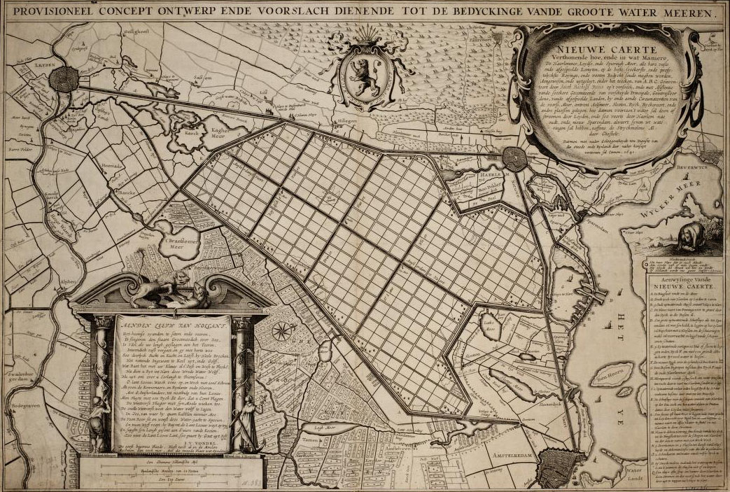
In the middle ages there where tree large peat bog lakes between Amsterdam, Leiden and Haarlem called the Spieringmeer, the (old) Haarlemmermeer and the Leidschemeer.
Because of peat winning and wave reduction from the banks of the lakes, the tree lakes became one around 1500 ac. The new lake was called (new) Haarlemmermeer. The draining of the Haarlemmermeer started in 1849, it lasted until the first of July 1952. after the draining of the Haarlemmermeer, Hoofddorp was founded in 1853 by the name Kruisdorp. In 1868 the name Kruisdorp chanced in to Hoofddorp because there already existed an village called Kruisdorp in the Dutch province Zeeland. Hoofddorp is the capital of the municipality Haarlemmermeer.
The municipality Haarlemmermeer is situated to south-west from Amsterdam (capital of Holland) and to south from Haarlem. In to total there are ten towns and villages in the municipality Haarlemmermeer. Those towns are Hoofddorp, Nieuw-Vennep, Lisse, Heemstede, Vijfhuizen, Rijzenhout, Sassanheim, Voorhout, Hillegom, Abbenes The municipality Haarlemmermeer is situated in Noord-Holland.
The Haarlemmermeer can be reached by the highway A4 from Amsterdam to Delft the A9 From Alkmaar to Amsterdam also crosses the Haarlemmermeer. The south side of the Haarlemmemeer is connected with Leiden by the highway called A44. The Haarlemmermeer has a railway connection with a station in Hoofddorp. The Haarlemmermeer is surrounded by the Ringvaart (a canal). This canal is used for pleasure shipping and transport by water. The largest airport of Holland uses the canal for supply of plain fuel.

)