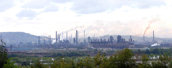
The panoramic view of
Industrial area of
Magnotogorsk (Fig.1)
source: Konishova, 2005
(http://archvuz.ru/number
s/2010_2/018)
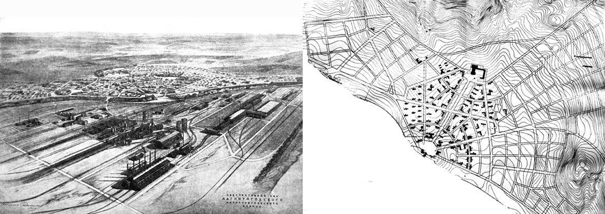
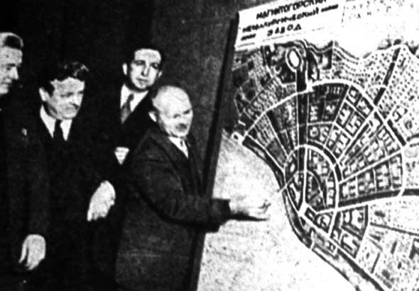
The initial urban layout
draft of the settlement
near the industry by
Lengipromez, 1928 (Fig.2)
source: http://archvuz.ru/numbers
/2010_2/018
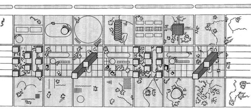
The Concept of ideal city
by I. Leonidov. The
linear composition of a
city in thought out is
such a way that connects
the industrial complex
with the agrarian one.
The linear composition
includes the design of
leisure public zones with
dots of public facilities
along the line. The
buildings are designed as
tall glass towers and
low-rise housing. The
bridges are cast over the
motorways connecting the
neighborhoods with each
other. (Fig.4)
source: http://arx.novosibdom.ru/
node/2385
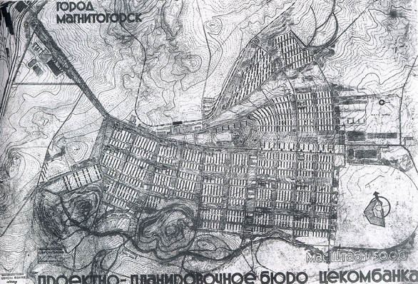
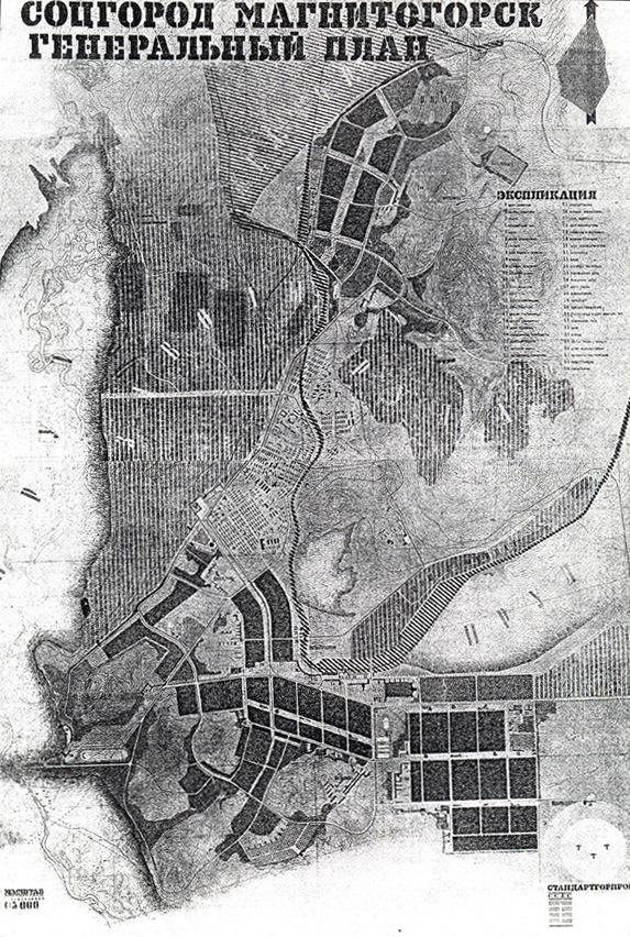
The master plan of
Magnitogorsk by E. May.
1930. (Fig.5)
source: http://archvuz.ru/numbers
/2010_2/018
The masterplan of the
city of Magnitogorsk by
E. May. 1931. (Fig.6)
source: http://archvuz.ru/numbers
/2010_2/018
The scheme of the
built-up ares (filled
black) and the masterplan
of the city of
Magnitogorsk on the
west-side (hollow).
1933-1934. (Fig.7)
source: http://archvuz.ru/numbers
/2010_2/018
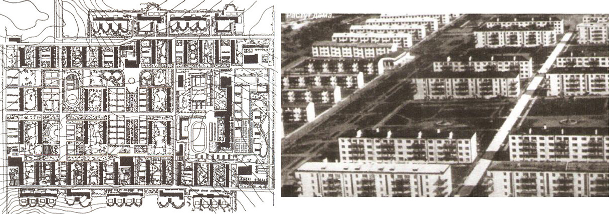
The masterplan (left)
(1931) and airphoto
(right) (late 30s) of the
neighborhood 1 of the
Sotsgorod Magnitogorsk.
E.May. (Fig.8)
source: http://archvuz.ru/numbers
/2010_2/018
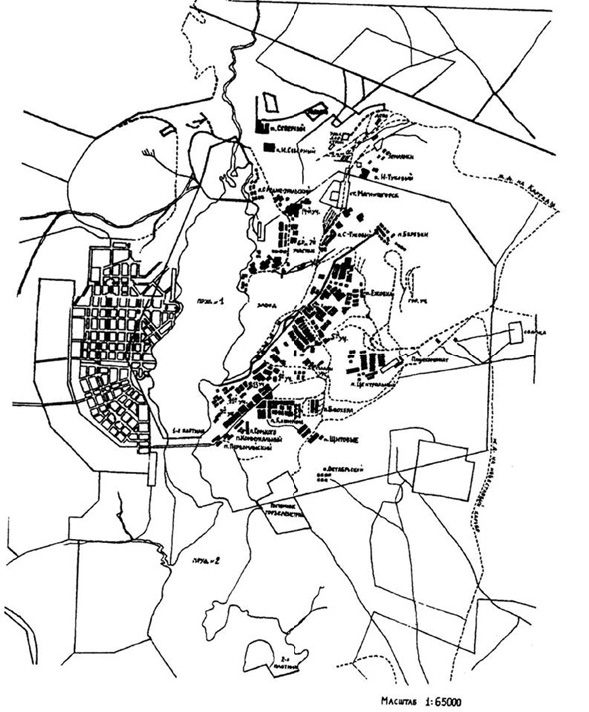
The map of the city of
Magnitogorsk in 2010.
(Fig.10)
source: http://www.magnitka.ws/к
арта-магнитог
орска.html
|
General information:
Magnitogorsk (Russian: Магнитогóрск) is a city in Russia's Volga-Urals Region. It is one of the major centers of heavy metals production (steel and iron). The city housed 418.545 people in 2002 which makes it the second largest city in Russia which does not serve as an administrative center of federal subject or an administrative division. At the moment the city counts 6 major industry bases including the original Iron and Steel Plant (Magnitogorsk Iron and Steel Works (MISW or MMK)).
Development:
In may 1925 in the city of Sverdlovsk the planning process of the Iron and Steel Plant began in accordance with the GOELRO*. The place chosen for the factory was situated near the mount “Magnitka” and the earlier Cossack's fort-like settlement on the eastern side of Ural river. As in many cases, the priority in the location choice was given to the industry and the approximate production capacity of the plant was predefined. In 1926 the project was passed over to Saint-Petersburg (Leningrad) Institution Of Steel Factories and was from that moment on was controlled by the both organizations. In the year of 1929 the development officially began with the first building workers arriving at the site. In the same year they started with the building of the settlement to serve the future plant.
* GOELRO plan (Russian: план ГОЭЛРО) was the first-ever Soviet plan for national economic recovery and development. It became the prototype for subsequent Five-Year Plans drafted by Gosplan. GOELRO is the transliteration of the Russian abbreviation for "State Commission for Electrification of Russia" . The Plan represented a major restructuring of the Soviet economy based on total electrification of the country which goal stretched however beyond the electrification only and included the organization of industry on the basis of modern, advanced technology.
Source: http://en.wikipedia.org/wiki/GOELRO_plan
The plans for the worker settlement implied the construction of a settlement able to house 20 thousand people (that was about the calculated number of people needed for servicing the plant – the so-called labor balance method). The settlement was planned to be located in the immediate proximity of the industrial area. Fig.2. The project was now passed on to the Supreme Soviet of the National Economy where the architect S. Chernishov took his leadership (1929). As the number of inhabitants kept changing due to the uncertainty in the desired production capacity of the industry, Chernishov began to experience some difficulties defining the concept of the settlement. The situation in the country indicated a rapidly growing need in production and housing stock. Fully aware of these prospects and intending to make the plans maximally realistic and feasible he decided to split the whole construction process into two series. First one – being the temporary settlement, and second one – the permanent one later on. Chernishov provided a plan of the city. Fig.3.
His plans, however, were not approved but received some critique including from N. Milyutin who criticized the traditionalism and old-fashion style of the proposal. In his review he stressed the new socialist request, the needs for new definitions of the housing and municipal building meant to present the new socialist domestic order. He gave some comments as to the new status of women and their new role in the new society, to the necessity to create maximally comfortable (climate and service) conditions for living, and to the necessity of a new basis for the population employment estimation, to the importance to address the issues of the new ways of social upbringing of children and surveillance. He called for the need for expression of a new socialist life style in urban planning and architecture. In other words, a city structure would have to be developed that in terms of its entire genesis as well as in terms of its internal articulation and structuring would be fundamentally different from the capitalist cities in the rest of the world.
It is assumed that as a consequence the adaptations were made to the original planning demands indicating this time the expected qualities and characteristics of the future city and defining it as a new type of Soviet town or “sotsialisticheskiy gorod” (“Sotsgorod”). The decisive parameters of a new city were set characterized by “full employment of all capable population in production or servicing”, “optimum accessible nationalization of life style”, “fully equipped with municipal and cultural facilities as well as with health care establishments, children facilities and overall comfortable environment for living” (Sovnarkom, 1929).
Some demands gave fully concrete parameters for the project. Such as the housing typology. The preferred housing type was 4-5 story apartment blocks mostly of communal type houses and familylike hostels. Apart from the living, the demands included indications on technical equipment such as the all the necessary communications, electricity, water, etc. and on social equipment such as the public rooms, spaces for cultural and creative activities, public gatherings (Dom Culturi, Dom Truda), cantinas, laundries, public saunas, various sport facilities, day care, health care, educational services, etc. The strong emphasis was put on the liberation of women from the traditional household tasks and the opportunity to employ themselves along with the men. For these purposes, kindergarten facilities had to be introduced and located in an immediate proximity. All these measures we seen as the basics for the maximal socialization of the life style.
However, even though the general principles for the planning of Socialist cities had been established, the vision for the urban practical solutions was still unclear and blurry. In this relation, the Union-wide competition for the new concept was launched on which the total of 16 projects were presented. Fig. 4. Five of these projects were officially ordered by the state and the rest were the private initiatives including the projects executed by amateurs and common people.
All the projects were rejected for either they were too idealistic or far too unfeasible. The reality was that on top of the The Council of People's Commissars (Sovnarkom) (Russian: Совет народных коммиссаров or Совнарком) interests the interests of the direct investor – Magnitstroy Building Company – were embedded. These interests included the minimum expenses and building work capacity. The exchange between the dwelling areas and industrial sites had to be the most efficient (this included either the walking distances or available public transportation). Everything was back to the beginning: to the absence of approved plans, to the laborious work of architects, and parallel construction of unregulated and random housing on the site. In 1930 the situation was worsened by the newly established size of the buffer zone between the industries and living areas. This measure limited to even higher extent the size of potential territory available at the left side of the Ural River for the city. Confined between the hills, mountains, the river, and industry the settlement could only house a limited amount of inhabitants and had less than a little prospect for growth. The discussions concerning the relocation of the dwelling site were highly debated. The necessity to relocate the part of the city to the west-side of the river was now being faced by all the participants involved.
In the Autumn 1930 the delay in construction and the absence of clear plans were perceived as disastrous and threatening to the scheduled launching of the plant itself. In order to improve the situation, the special department for the financing of the construction of the Soviet New Towns was formed at the base of the State Bank and in the same year the State Bank invited German architect and urban planner Ernst May accompanied by some other foreign architects to participate. From that moment on, three master plans were being developed – one by Ernst May, second by GIPROGOR (State Institute for the Planning of New Towns) under the surveillance of Chernishov, and the third one is led by the architect Davidovich.
Few months later the group of Chernishov presented the west-bank project that is immediately labeled by the especially for these reasons assembled group of experts as a good project and “complying to the demands”. The east-sided project of May received some critics as of much too rigid and homogeneous character, giving it a barrack-like look. Some negative remarks were given to non-uniformity in the accessibility of the distributed building groups as well as the the undesirability to combine the public center with the functional (station) one. Fig. 5. All the odds seemed to favor GIPROGOR and Chernishov. The experts highlight, however, that neither projects have succeeded in finding ideas of what the healthy socialist settlement should be like altogether.
It is important to note that at that point all the architects and planners became hostages of the huge bureaucratic machine where the different institutions and committees involved were pulling their strings. This made the decision making extremely difficult and uncertain. So, just few month later the project of Chernishov was declined reasoned by the absence of a one strong center and E. May obtained his go-through. His project was supported by the State bank and by Magnitstroy. The advocates for the eastern side indicated that the industry and therefore the settlement would not grow and that the solution for the eastern side is undoubtedly cheaper and more feasible which was certainly important as the situation was to be solved as soon s possible. However, the situation kept swapping between the eastern and western banks as the influence of the different organization changed. The arguments (and consequently of the E. May group) for the east-side were: 1) the optimal proximity to the industry (Steel and Iron Factory, sintering plant, mining sites) as far as the buffer protection zone allows. The May's plan took into account three gates to the industrial site: the main was situated 2 km away from the bulk of the city, the southern entrance is 1.5 km away. The first living quarters were located 60 meters above the level of the industrial site which combined with the distance should provide sufficient enough protection against the smog according to the planners. References to the Ruhr areas confirmed the theory they stated. Moreover, during the site visiting, the studies of the prevailing climatic conditions and winds in particular had proved that the right side is as well as the left side is vulnerable to the smog pollution. The arguments for the east-sided project were also advocated by Mostakov – a Russian member of the May's group. He argued that current movement in international urban practice disapproved the construction of big cities. The dispersed concentration of smaller towns near factories and employment is actual and most efficient. He also proposed not to assign any space to parks as the new socialist town should be a garden-city.
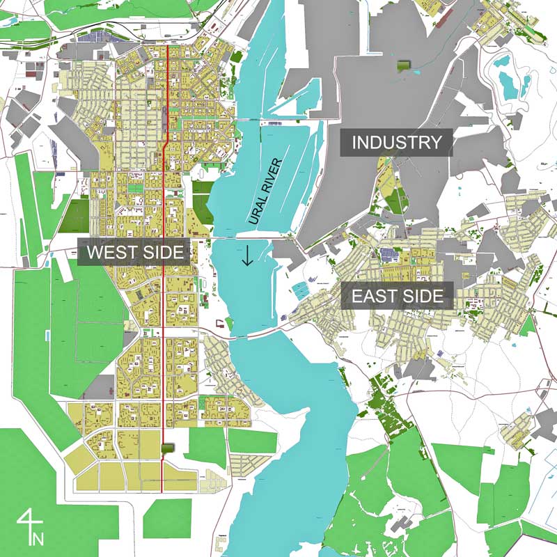
The arguments to the west-sided city planning were the possibilities for the expected growth to up to 250 000 inhabitants and more and possible status change into the administrative center, the naturally occurring buffer zone (water) between the city and the factories (Fig. 10), the terrain on the western side of the river was more favorable for construction and exploitation of the cityscape, accessibility to the water, better regional accessibility (connection Magnitogorsk – Ufa), and the wind predictions that according to them favored the right side in all respects.
In February 1931 the new player appeared (The Regional Ural Planning Committee) which persisted on the necessity to urbanize the western side and allow for the future expansion. Their decisions were based on the analysis of reality not so much on the calculated predictions. Regional Ural Planning Committee revealed that the perspectives and needs for the growth of such cities are high and the future population was likely to reach the 400 000 people they said.
After the thorough examination of both proposals the May's project was declined once again and the final conclusion was carried out by the Scientific and Technological department of Sovnarkom in favor of the west-side development. On the 20th of March the official decision (number 344) was implemented by The Council of People's Commissars that approved the construction of the city of Magnitogorsk on the right side of the river. However, the Supreme Soviet of the National Economy (VSNKh) remained unsatisfied with this decision and motivated by the bulk of the work already done for the east-side, on-going construction, and the need to speed up the implementation, continued the planning (May) on the east-side. Fig. 6.
While the plans and documentations were being prepared the situation on the site had changed. Now it became obvious that the city needed to be constructed on both sides providing a certain percent of the housing stock in the immediate vicinity from the industry. The projects for the left side were needed but the situation was complicated by the ongoing random and unregulated constructions. By the year 1932 the unregulated and unplanned settlements had filled the area around the industry. Fig.7.
To sum up, by the year 1933 the fight for the development of the left-side was almost lost. The only part successfully implemented was the neighborhood number 1 of May's project. Fig. 8. The rest of the project developed for the three years has never been implemented. In 1934 May and his group left Soviet Union. In the same year the development of the west-side was passed to the group of B. Dandich and V. Popov where the estimated population was set as 300 000 people this time. The east-side of the city, however, for the long time remained the main building site and dwelling area for the first inhabitants and workers. As May's group had predicted, the lack of financial support to implement the infrastructure connecting the west-side area hampered the construction works throughout the later 30s and the 40s. The shifting point occurred only after the World War and in the view of unfolded mass post war reconstruction the big scale constructions finally moved to the other side of the river. The time for the long-searched socialist city had finally come to fulfill itself and demonstrated the might of the city-forming industrial facilities.
It 1959 the housing stock of the west-side had outnumbered the east-side and had reached 51%. Overtime the main city activities had moved to the right-bank which had been keeping gaining urban significance. By 1966 the housing stock reached 70% and at the present moment accounts for 90%. The east-bank remains highly industrial and houses all the city's grown factories and plants. Fig. 10. The dwelling area of that site still bears the character of the initial random growth – highly scattered and consists mostly of an individual housing stock. Fig. 10.
Conclusions:
The history of planning of “socialist city”of Magnitogorsk illustrates the soviet planning priorities during the early five-year plans. The industrial goals were above all. This resulted in neglected living conditions of the early workers and builders. And the fact that the decision regarding the city were made based entirely on the benefits of this industry it resulted in a failure to take into account the urban and social reality of the time. The architects and planners were the hostages of a huge bureaucratic machine that hampered the process of decision-making and consensus reaching. The apparatus for the new town planning was still in the development and could not function efficiently yet. The foreign architects and planners, although failed, did contribute to the development of soviet urban planning. The method and approaches of the May's group were noticed and integrated into consequent planning of Soviet New Towns the image of which was well on its way.
source: http://archvuz.ru/numbers/2010_2/018
http://rosswolfe.wordpress.com/2010/10/01/ernst-may-“city-building-in-the-ussr”-1931/
http://en.wikipedia.org/wiki/Magnitogorsk
http://www.maglive.ru/
http://www.magnitka.ws/карта-магнитогорска.html
http://mgorsk.ru/person/258935.html |

)
)
)
)
)
)
)
)