- Anacker, Shonin. “Geographies of Power in Nazarbayev’s Astana”. In: Eurasian Geography and Economics, 2004, 45, No. 7, pp. 515-533.
- Capital, (forthcoming, 2010). Directed by Joe Bender and Maxim Pozdorovkin. Third Party Productions, Cambridge, 2010.
- Dmitrieva, Marina and Kliems, Alfrun. The Post-Socialist City: Continuity and Change in Urban Space and Imagery. Jovis Diskurs, Berlin. 2010.
- Huttenbach, Henry R. “Whither Kazakstan? Changing capitals: From Almaty to Aqmola/Astana”. In: Nationalities Papers, Vol. 26, Issue 3 September 1998, pp. 581 – 587.
- Japan International Cooperation Agency. The Study on the Master Plan for the Development of the City of Astana in the Republic of Kazakhstan. 2001.
- Kurokawa, Kisho. The Philosophy of Symbiosis. Kodansha International, 1997.
- Schatz, Edward. “What Capital Cities Say About State and Nation Building”. In: Nationalism and Ethnic Politics Vol. 9 Issue 4, 2004. pp. 111-140.
- Schatz, Edward. Modern Clan Politics: The Power of "Blood" in Kazakhstan and Beyond. Seattle: University of Washington Press. 2004.
- Wright, Herbert. Instant Cities. Black Dog Publishing, London. 2008.
type of New Town:
> scale of autonomy
New-Town-in-Town
Satellite
New Town
Company Town
> client
Private Corporation
Public Corporation
> policy
Capital
Decentralization
Industrialization
Resettlement
Economic
source:
Astana is the brainchild of Kazakhstan President Nursultan Nazarbayev. As an expression of national identity in the wake of independence, the new capital features massive boulevards and a collection of iconic architecture. After two decades in power, Nazarbayev has shaped the new town almost precisely to his will, despite masterplans by Kisho Kurokawa that incorporated Metabolist elements.
Astana, the city of many names, is the present capital city of Kazakhstan, the world’s largest landlocked country by land area located in Central Asia. This area is also the second-largest producer of crude oil, since 1997, replacing the previous capital called Almaty.
The history of the city dates from 1824 when it was founded by Siberian Cossacks, coming from Russian Omsk, and named as Akmolinsk. The city of Akmolinsk thrived as a merchant town until the mid-20th century. The early 20th century is seen as one of the groundbreaking moments, during which the city became a major railway junction, causing an economic boom until the Rusian Civil War (1917-1922).
During the socialist reign of J. Stalin, the city as well as the country hosted several Soviet gulag labour camps. Furthermore, just outside the contemporary city boundaries there stood one of the most notorious camps called Akmolinskii Camp for Wives of Traitors of the Motherland (ALZHIR).
In 1961 the city was dubbed Tselinograd, meaning ‘Virgin Lands City’, as a result of Nikita Khrushchev’s mass grain cultivation plant known as Virgin Lands Campaign. The plant was meant to boost agriculture production and thus decrease shortages of food, whose centre was Astana.
After 29 years, on an occasion of the declaration of independence from the Soviet Union, the city got a new name – Akmola, or ‘White Temple’. However, the name remained only for a couple of years. By late 1997, after the official relocation of the capital, happening for safety reasons due to possible seismic activities, the city ultimately became Astana. The name means ‘Capital City’.
Master plan
The New City was designed under the direction of the Japanese architect Kisho Kurokawa. He was influenced by Kazakhstan’s President Nazarbayev (nicknamed ‘Papa’), and he played a key role in the design process as well as decision-making, thus there is no wonder that Nazarbayev himself consider his own person as an author of Astana. Furthermore, it seems that all country, all economic sectors are under his control, including a state-owned national oil company KazMunaiGaz (KMG), giving him a direct control of the petroleum sector.
Despite the victory of Kurokawa in the international competition for the master plan and design of the New City of Astana, Kurokawa was forced to go with the master plan of the Saudi Bin Ladin Group. Ultimately, the government cancelled this proposal and moved forward with just Kurokawa. Furthermore, during the construction, the plan was revised a couple of times.
The new capital was designed as a ‘Metabolic City’. As the city would grow and change over time, it would adapt to shifting circumstances and be able to accommodate around 900,000 people by the year 2030. The proposal preserves and redevelops the old city of the Ishim River and the south and east are intended for a new city. This combination creates a symbiosis between the history and the future.
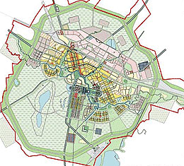
The influence of the authorities was so great that major changes could not be made to the original plan. However, some major aspects survived - a ring of green around the city, serving as a wind fence; a rounded shape or a programmatic division. The majority of the Old Town residential areas were squeezed between the Ishim River to the south, and massive net of train tracks to the north, to industrial areas additionally interlaced by Sofievskoe highway. The tracks cut through the city on their way across the country.
The city is divided into three administrative districts – Almaty District (on the northern bank of the River of Ishim), comprising mainly the Old Town and new industry; Esil District (on the south bank), serving as the commercial and governmental centre; Saryarka District (east of Almaty District), including a part of the Old Town as well as new residential, industrial and commercial enterprises. Among these administrative districts, there are ten Market Zones.
The Industrial Zone covers the area at the northern edge of the city, extending more than 15 kilometres across the city’s northern periphery. It is considerably larger than any of the zones. On the contrary, the Riverside is one of the city’s smallest districts characterized by a mixed-use programme of retail, office building and (upper-class) residential developments.
To the north of the district, there is the Old Centre which is still perceived as a heart of commercial activities. Furthermore, an extended part of the centre acts as a sort of buffer zone between the dense city centre and the heavy industry. Most of housing blocks of three to five floors come from the 1950’s and 1960’s. More modern residential areas, between 1970s and 1980’s, are just east of the extended centre, in the Micro-districts Zones.
The South-East Zone is characterized by primarily new housing organized along strictly gridded streets. Houses are relatively larger with front and back yards walled in by concrete-block fences.
Ak-bulak, Energetic and Chubary, lying in the geographical centre of the city, are purely residential zones. Most of houses are newly constructed, but some of them remain from previous eras.
On the city’s western side, we could find another residential section, so-called Karaotkel Zone with newly-built houses. The central government and cultural facilities are placed almost in the centre of the city, on the south side of Ishim, in the Zarechy Zone known as Government City. The western origin of the Zone is identified by the world’s largest tensile construction, the Khan Shatyr Entertainment Centre of a tent-like structure by English Foster + Partners, participant in other projects within the New Towns around the world, for example Tianjin Eco-City (People’s republic of China). The Khan Shatyr shelters more than 100,000 square metres of indoor recreation space; full of cafes, restaurants, shops, cinemas and other leisure activities.
Moving further east along the governmental axis, the ninety-seven high Bayterek Tower considered a city’s symbol and two golden ministerial buildings, indicating the entry to the Presidential palace (Ak Orda), soar gradually. The richly designed Palace, at the end of the axis, sits at the midpoint of a sculpted semi-circular garden with terraced steps, leading down to the shore of the Ishim River. On the other side of the river, the pyramidal Palace of Peace and Reconciliation, another Foster + Partners’ building, stands. The sixty-five metre high building symbolises Astana’s commitment to diversity and religious tolerance. Next to the Palace, one of the largest concert halls rises up – the Central Concert hall by the Rome-based firm, Studio Nicoletti, seating 3,500 spectators. The shape of the hall was purposely made to resemble a traditional Kazakh instrument known as a dombra.
Results
The building of the city itself took officially 10 years; however, some areas were finished later.
As for the funding, the final price is unknown. Available estimations begin at $400 million.
Nevertheless, it is clear that the city’s growth has been financed largely by the oil and gas sector and also by foreign investment.
The global financial crisis in 2008-2009 caused a dramatic fall of real estate prices which have fallen by 58% by the end of 2007.
In comparison with other New Towns, Astana does not face a lack of leisure and employment options, which plague most New Towns.