- Prins, Dorothee, ‘Kunst zum Anfassen. In Sennestadt wird Kunst "unters Volk" gebracht’, Der Minden-Ravensberger 59 (1987), 94.
- Linke, Volker, Vorort, Satelliten- und Trabantenstadt. Ein Beitrag zu Entwicklungstendenzen und zur Terminologie von Kernstadtabhängigen Siedlungen, dargestellt und den Beispielen Köln-Chorweiler, Hamburg-Norderstadt, Biefeld-Sennestadt und Köln-Erfstadt, Köln 1977.
- Kluywer, Peter, Nieuwe steden. Een verkenning van verstedelijkingsprocessen, Paris/Amsterdam 1970.
- Reichow, Hans Bernard, Organische Stadtbaukunst, Braunschweig 1948.
- Reichow, Hans Bernard, Die autogerechte Stadt. Ein Weg aus dem Verkehrs-Chaos, Ravensburg 1959.
- Schulz, Frank, David R. Froessler, Dominik Erbelding, Die Sennestadt hat Zukunft. Kooperativer Leitbildprozess Sennestadt, Düsseldorf 2008.
- Sennestadt Stadtpläne 1987 und 2005. Sennestadt in Bielefeld – ein Stadtbezirk stellt sich vor. 1987. Gefalteter Stadtplan im Massstab 1 :150000 mit Informationen und Abbildungen auf der Rückseite. 2) Sennestadt. Stadtplan 2 […]
- Sennestadtverein, Wagnis Sennestadt, Bielefeld 2005.
- Steinfeld, Thomas, ‘Sennestadt. Pepitahut mit Anspruch auf Besonnung. Eine Erinnerung an eine soziale Utopie’, Süddeutsche Zeitung, April 12. 2003.
- Stratmann, Franz, Karl Gerlach, Max Kluge and Otto Wiehage, Sennestad. Geschichte einer Landschaft, Bielefeld 1968.
type of New Town:
> scale of autonomy
New-Town-in-Town
Satellite
New Town
Company Town
> client
Private Corporation
Public Corporation
> policy
Capital
Decentralization
Industrialization
Resettlement
Economic
source: P. Kluyver, 'Nieuwe Steden, een verkenning van verstedelijkingsprocessen', Amsterdam 1971
Introduction
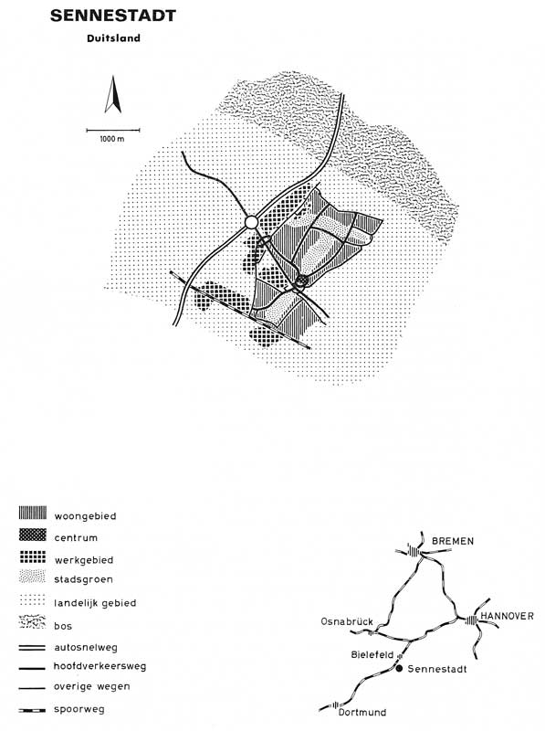
Sennestadt is located in West Germany, in the southeast of Bielefeld, in the federal state Nordreihn-Westfalen. Sennestadt is planned as a new residential town to comply with the housing needs after World War II, for the most part for refugees. Because of this, the Minister of Construction of the federal state of Nordrhein-Westfalen decided in 1954 to raise a New Town with living quarters for over 300,000 inhabitants and employment in the Bielefeld region: Sennestadt. The location of Sennestadt in the South-East of Bielefeld was determined by the ministry and the federal state government, because of the low land price and the good connections: highway A2 to Cologne-Hannover-Berlin, the Bundesstrasse 68 to Osnabrück-Paderborn, the public transport connections to Bielefeld Paderborn and the airport. The land consisted of dunes and sand hills where agriculture had never taken place. The geographical situation caused large variation at ground level. The Sennestadt GmbH was founded in 1956 in cooperation with the Bielefeld department, the municipality of Senne II and the Landscape Association of Westfalen-Lippe as the driving forces to realize the urban plan. The goal was to develop a large settlement in a green environment.
Urban plan and design
The federal planning act, a master plan for the regional planning of the German Federal States, made it possible to create new settlements according to expansion plans. Hans Bernard Reichow (1899-1974) became chief architect after winning the first prize of the design competition. Reichow designed the city according to his 'organic city' idea. In his publication Organische Baukunst, organische Kultur (1949) he criticized the monotonous anonymous living environment. The organic city would, in contrast, provide an attractive habitat with a human scale: a balance between culture and nature with attention to the needs and traditions of the inhabitants. Reichow divided the city into eastern, western, northern and southern parts, but only the northern and southern parts were realized. The centre connected the two parts. The centre had a circular form and was surrounded by water, to make it look like an island. The city had an 'organic' structure with curving streets and flowing brooks to make it a more charming environment for the inhabitants than rigid, orthogonal urban plans. The one-family houses were placed in rectangular four-storey slabs constructed according to the Plattenbau-method with saddle roofs. Only 10 percent of the total amount of houses were one-family dwellings, but this increased over the years. Along the major roads and at the borders of the green areas high building complexes of eight to eleven storeys functioned as landmarks. Reichow also designed an elaborate road network that was based on his later publication Die Autogerechte Stadt, Ein Weg aus dem Verkehrschaos (1959). The street plan was formed by an intersection of the main street, the Bundesstrasse Kassel-Osnabrück, the highway to Hannover and the Ruhr area, alongside the north of Sennestadt, and the railway, along the western side connected to a ring road. Foot- and bicycle paths were separated from the roads to guarantee the security of the inhabitants.
Realization
The city came into existence between 1958 and 1964. The first project to be realized was an industrial area, to the northwest of the city, between Lümmershagener Strasse and the highway, with factories for the production of metal, wood, printing and textile crafts. When a large amount of houses were already delivered by 1965, Senne II became an independent city with city rights: Sennestadt. In the seventies Sennestadt was enlarged through the annexation of Echarsheim, to the south of Sennestadt. The population grew because of the increasing numbers of inhabitants that were attracted by the employment opportunities. The newcomers settled in the high-rise building complexes and new factories were situated most part in the annexed areas of Sennestadt. In spite of the growth, Sennestadt lost its independent status in 1973 and became part of the municipality of Bielefeld.
Present situation
At the end of the nineties and the beginning of the 21st century the land use and social structure had changed and the city was degenerating. The city had been aging with the large amount of elderly. The younger generation left because of high unemployment (12,5% in 2007). In 2007 the population of the 24.7 square kilometres large area numbered not more than 21,500 persons. In the same year the municipality started a city development program in cooperation with the citizens to improve the infrastructure, modernizing residences according to present needs, constructing facility buildings and a city ring to accomplish this much-needed modernization. At first a development plan was made that could be changed in accordance with the visions of the inhabitants. In May 2009 the urban plan was presented at the town hall after which the first construction activities would start for the transformation of Sennestadt. Apart from the spatial structure, the municipality also wants to change the figure of Sennestadt from an outskirt of Bielefeld, to an attractive residential area.